
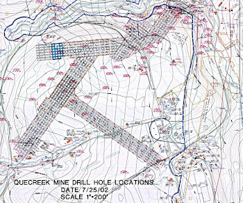
PA Mine Map Atlas Has Served State Since The Quecreek Mine Rescue In Somerset County
PA Environment Daily
JULY 10, 2023
Managed by Pennsylvania Spatial Data Access (PASDA), which is a part of the Institutes of Energy and the Environment, in partnership with the Pennsylvania Department of Environmental Protection (PA DEP), the Pennsylvania Mine Map Atlas houses over 100,000 high-resolution scans of original mine maps, which are overlaid onto a modern map of the state.


Let's personalize your content