This article is part of a special report on the total solar eclipse that will be visible from parts of the U.S., Mexico and Canada on April 8, 2024. It was updated at 11:34 A.M. EDT on April 8.
Millions of people living in the 115-mile-wide path of April 8’s total solar eclipse—and the millions more who will travel to catch the awe-inspiring astronomical event—are crossing their fingers that the weather will cooperate for an eclipse that will be the last in a generation.
For those anxiously refreshing the forecast page, the tough news is that cloud cover and precipitation are much trickier to predict than temperature. This is because the former involve so many small-scale processes in the atmosphere, and each of these factors can change quickly, hour-by-hour and even minute-by-minute. These processes “are incredibly difficult to predict even in real time,” says Greg Carbin, chief of forecast operations at the U.S. National Weather Service’s (NWS’s) Weather Prediction Center. So even on eclipse day itself there won’t be total certainty; when mostly clear skies prevail, stray clouds can still roll by during the several minutes of totality (as frustratingly happened to this writer while viewing the 2017 solar eclipse in Nashville, Tenn.).
On supporting science journalism
If you're enjoying this article, consider supporting our award-winning journalism by subscribing. By purchasing a subscription you are helping to ensure the future of impactful stories about the discoveries and ideas shaping our world today.
To help eager eclipse watchers prepare, Scientific American is keeping up with the daily forecast across the U.S. path of totality—which will move from west to east, beginning at about 1:27 P.M. CDT in Eagle Pass, Tex., and ending at about 3:35 P.M. EDT in Houlton, Me.—and is offering detailed information for a few major cities below. Forecasts are mostly locked in as of Monday morning, but conditions could still change in some spots as it gets closer to the time of totality. If and when they do, we’ll be updating this article.
Based on climatology (the long-term average weather conditions in a particular place at a particular time of year), the best bet for clear skies would have been expected in Texas, with the odds of cloudy conditions increasing as one moved northeast along the eclipse path. But those expectations are just an average. Weather is inherently chaotic and especially so in spring. The weather on eclipse day is looking like a flip of the climatological pattern.
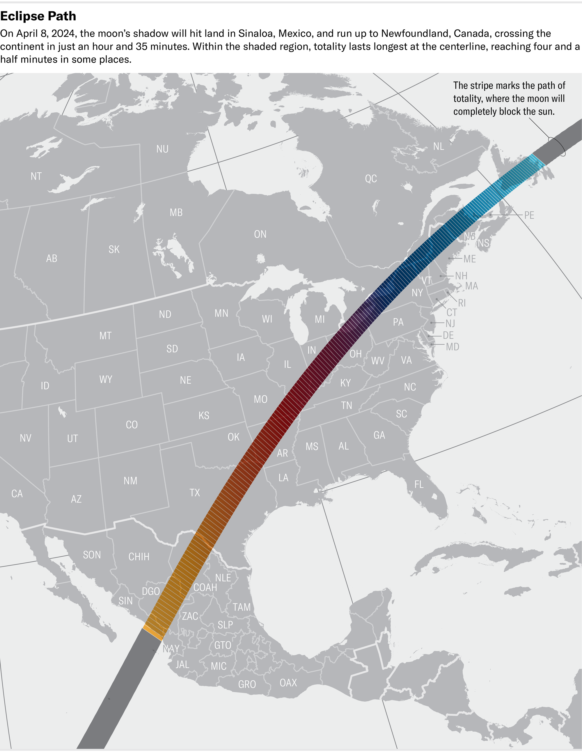
Credit: Katie Peek; Source: NASA (eclipse track data)
Generally dry areas such as southern Texas are more likely to see clear skies at this time of year because there is less moisture available to build clouds. But near the Great Lakes and in New England, ground that is sodden from spring rains and lingering snow can provide ample moisture for clouds—especially when relatively warm spring breezes sweep through and promote evaporation.
April is part of “the transition season from the cool to the warm season,” Carbin says, noting that “the transition seasons are notoriously difficult” times in which to forecast weather. In part, this is because the jet stream—the vast, high-altitude river of air that guides storm systems across the continent—covers a good portion of the north-central U.S. Storm systems come with a higher degree of prediction uncertainty than stable air masses of high pressure, which generally bring clear skies. This year is particularly tricky, Carbin says, because the currently active El Niño climate pattern means another jet stream, known as the subtropical jet, is relatively active over the southern portion of the country.
Today a low-pressure system is shifting into the Mississippi Valley. And an associated front, which separates warm and cool air masses, is extending down into the south-central U.S., where it is expected to stall.
Along the entire path of totality through the U.S., there are chances of severe weather and flash flooding in Texas, southern Oklahoma, and southwestern Arkansas and some chances of rain in Ohio, northwestern Pennsylvania and western New York State. Cloudy conditions are highest from Texas into southern Arkansas, and clouds may block the view in Ohio, northwestern Pennsylvania and New York State, according to the NWS. The best chances of clear skies are in northern New England and possibly from northern Arkansas to central Indiana. (The cloud cover shown on the map below does not specify whether those are low-level or high-level clouds.)

The areas shaded in gray are where cloud cover is more likely today, with grayish-blue and light blue denoting areas with possible cloudy conditions. Unshaded areas are more likely to have clear skies. This forecast is from April 8.
NOAA’s Weather Prediction Center
With just a few hours to go, there is still some uncertainty in the passage of cloud cover in some areas, particularly from Arkansas up into Ohio.
Even as the broad patterns of the jet stream and air mass movement have become clearer today, “the devil’s in the details,” Carbin says. At best, forecasts on a given day can still only give expected conditions hour-by-hour—and the eclipse will happen on the scale of minutes. It’s impossible to say exactly where a downpour or a puffy cloud will pop up. Carbin likens it to a pot of boiling water: You know that bubbles will form, “but can you predict where that first bubble will come up?”
The eclipse itself could actually be a boon if puffy white clouds prove to be the only potential obscuration: a recent study found that in a 2005 eclipse over Europe and Africa, low-level cumulus clouds actually dissipated during the event. Such clouds form when warm, moist air rises from the ground, cooling and condensing into droplets. An eclipse’s blockage of the sun’s rays can quickly cool the land’s surface temperature—disrupting the cloud-forming process.
And if clouds do fully obscure the skies, here’s how to watch the eclipse online.
Below are the current forecasts for select cities on the eclipse’s path.
San Antonio, Tex. (Totality begins around 1:30 P.M. CDT)
Clouds have already started rolling in on Monday morning, and the skies are likely to remain mostly clouds across southern and south-central Texas through the day. Some breaks in lower-level clouds are possible—though exactly when or where cannot be predicted in advance. High clouds will still remain, though, creating a milky layer high in the sky. Rain and severe weather are possible in southeastern Texas, particularly later in the afternoon.
Dallas, Tex. (1:40 P.M. CDT)
A low, dense layer of stratus clouds is moving northward from southeastern Texas, but the NWS currently forecasts a fair amount of scattering in that cloud layer, which would offer decent viewing windows, between 11 A.M. CDT and eclipse time in more northern areas. There will still be higher cirrus clouds in place. If they remain fairly thin, viewing conditions should still be fair. Some areas could see denser amounts of these clouds, though it is impossible to say exactly where that will be. Central Texas is likely to be under denser, lower-level clouds through eclipse time.
The best viewing conditions are still likely to be north of Interstate 20. As Sunday’s NWS forecast put it, “the farther northeast you go in the path of totality the more [likely] you are to see something.”
Rain and severe weather are expected in the afternoon after the eclipse, and authorities have urged people, especially visitors, to stay aware of the forecast and to make sure they have wireless emergency alerts turned on on their phones.
Little Rock, Ark. (1:50 P.M. CDT)
The forecast for Arkansas is largely unchanged, though details are coming more into focus. It’s unlikely that anywhere will be cloud-free, but northern and central parts of the state should only have to contend with a veil of high-level cirrus clouds. The most favorable conditions are likely to be along and northwest of the Interstate 30–U.S. Route 67 corridor. Southeastern Arkansas will likely have lower and thicker clouds, which will obstruct views.
Severe storms are expected in the southeastern region of the state later in the afternoon, with more than two to three inches of rain overnight and up to eight inches through Tuesday.
Indianapolis (3 P.M. EDT)
Conditions are looking drier and less cloudy in the region just in time for the eclipse this afternoon, with rain and lower-level clouds clearing out throughout the morning. High-level cirrus clouds are still expected to move in from the southwest, and there is some uncertainty as to how opaque those high clouds will be. This morning’s forecast from the NWS’s Indianapolis office was “cautiously optimistic” that the clouds will be fairly thin. Overall, it added, “trends are positive towards very good viewing conditions for most of the forecast area this afternoon.”
Cleveland (3:15 P.M. EDT)
Rain and clouds this morning should clear out of most of the area by about noon local time as a warm front passes through, though clouds are likely to remain in northwestern Pennsylvania and perhaps the very northeastern corner of Ohio. There will be high-level cirrus clouds entering from the southwest, however. These clouds won’t disrupt eclipse viewing too much, but their presence means there won’t be a completely unobstructed view.
Burlington, Vt. (3:25 P.M. EDT)
The threat of clouds has increased in the forecast, with high clouds expected to roll in over the area throughout the day and the potential for thicker, lower-level clouds to follow behind. High clouds will still allow for filtered views of totality. The clearest skies in the forecast area will generally be in the northeastern corner of Vermont, and the highest potential for clouds will be over northern New York State.
After a recent snowfall, authorities have warned viewers to stay off mountain trails because of concerns that melting could cause hazardous conditions.