As the Bootleg Fire rages across south-central Oregon and the Dixie Fire scorches Northern California, obliterating hundreds of thousands of acres of forest, the roiling flames have launched massive smoke plumes into the air. Typically, the smoke is lofted to a few kilometers above ground and then picked up and carried by wind currents across the country—much like weather fronts that carry moisture and bring rain—to blanket New York City and the Eastern Seaboard in a thick haze.
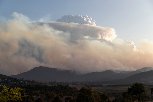
But the Bootleg has sent up a towering vertical plume, lofting smoke up to a record-breaking 16 kilometers. Intense hot fires from dense fuels; local weather conditions and dry surface; and high-altitude atmospheric clouds, conspired together causing the plume to rise far above ordinary clouds. When you see these pyrocumulonimbus clouds, or pyrocumulonimbi, you know you’ve got big trouble below. Known also by the abbreviation pyroCb, these clouds are are so intense that they modify local weather, producing intense downbursts, for example and creating amazing lightning storms that can ignite more fires.
In recent years, megafires and their blanketing haze have become an increasingly familiar sight, along with the towering thunderheads of smoke that form above them. Yet we’re only beginning to learn what causes those awe-inspiring “fire clouds,” what’s in them and what effects they have on weather on climate. Through a combination of field observations, experimental work in the laboratory and computer modeling at local to global scales, our team at Los Alamos National Laboratory is making progress in understanding the mechanisms and climate impacts of pyrocumulonimbus from recent megafires in British Columbia (2017) and Australia (2019–2020).
On supporting science journalism
If you're enjoying this article, consider supporting our award-winning journalism by subscribing. By purchasing a subscription you are helping to ensure the future of impactful stories about the discoveries and ideas shaping our world today.
This work brings benefits on two fronts. It will give us a sharper picture of what’s driving climate change, and it will help us develop more effective computer tools to fight fires and mitigate their danger.
THE HOT BREATH OF HELL
Pyrocumulonimbi have a story to tell. Looming in the stratosphere higher than Everest, these billowing clouds of smoke, moisture and gas appear only above the largest megafires, like the hot breath of hell. They lash out with lightning and even fire tornadoes, turbocharging local winds that feed the fire so it surges into unburned areas. This year, one fire in British Columbia generated 700,000 lightning strokes, as many strokes as B.C. typically gets in one year. The 2017 B.C. fires created five pyrocumulonimbus clouds in one day that pumped more than 220,000 tons of smoke into the lower stratosphere in just five hours.
That’s not all. By injecting soot and other particles known collectively as aerosols into the stratosphere—the lofty region of the atmosphere that starts several miles above the earth—pyrocumulonimbus clouds have the potential temporarily to alter the climate far from the source of the fire. The smoke blocks warming sunlight from reaching the Earth and lower atmosphere. In addition, the black carbon or soot can absorb sunlight, heating the air, which allows it to rise higher. This effect, discovered by Los Alamos’ late Robert Malone in 1985, has now been verified by observations. New research has found the 2020 Australian fires cooled the globe by about a tenth of a degree Fahrenheit—significant when every tenth of a degree counts in the battle against climate change.
With a goal of refining and calibrating computer models for wildfire and climate, we are studying pyrocumulonimbus clouds from the B.C. and Australia fires at several scales, from the molecules in the hot gases of a fire, to how the blaze moves across a specific landscape, to how smoke evolves in the atmosphere, and finally to how smoke travels around the glove. Our work also includes laboratory experiments and field observations about smoke gathered by our Center of Aerosol-gas Forensic Experiments (CAFÉ), where we study black-carbon emissions and their mixing with organic gases from fire.
We use these data to validate and refine our computer models, called HIGRAD and FIRETEC. Together, these computer tools help us study how fire moves across the landscape and interacts with the atmosphere. We then incorporate results into global climate models.
With this multiscale, interdisciplinary approach, we are able to simulate the evolution of all the gases and particles produced by a fire, from their combustion as wood, forest litter and other fuel to their ultimate fate as particles or droplets (aerosols) trapped in clouds and carried to far-distant sites. Understanding the evolution of those particles is key to understanding the genesis of pyrocumulonimbus clouds, their lifecycle and their impacts.
Our work is ongoing, but so far we have seen that, in addition to the B.C. 2017 fire lofting smoke, gas and particles, the condensation of water and ice on particles released latent heat that energized that lofting, increasing the plume height by about three miles to penetrate the stratosphere. Less than half of the mass of the smoke came from particles emitted by the fire itself. The rest formed by organic vapors condensing in the cold pyroCb updrafts, a surprising result.
MIXED EFFECTS ON CLIMATE
Global climate models allows us to study the consequences of this huge smoke injection event at a larger scale. In our simulations, the sun heated the black carbon in the smoke. In the stratosphere, solar heating increases the temperature of the atmosphere, unlike in the troposphere, where we live, where the air gets colder with altitude. This results in much more active weather in the troposphere and more sluggish weather in the stratosphere. As a consequence, smoke in the stratosphere can last for months to years while that in the troposphere rains out in a week.
Furthermore, soot in smoke absorbs sunlight that heats the air, allowing it to rise further (the Malone effect). Our simulations showed that the smoke reached over 12 miles in altitude, which is consistent with satellite observations. The smoke remained in the atmosphere about five months before settling out, which was also confirmed by observations. That relatively short time in the stratosphere limited the long-term climate impacts of the B.C. fire’s smoke, but regional shorter-term impacts on air quality were significant. Furthermore, the soot deposited on snowpack, oceans and other surfaces may contribute to warming and melting
We have also begun modeling the much larger and longer-lived New South Wales Australian megafires of 2019–2020. They injected up to four times more smoke into the stratosphere than the B.C. fires. Our preliminary analysis shows that this smoke was lofted by the same pyrocumulonimbus mechanisms and also by large-scale uplifting in the western Pacific. Solar heating added more energy, taking the smoke up to more than 15 miles. It stayed aloft for a year and a half.
Our modeling has not produced a definitive prediction about the global cooling effects of the massive injection of soot and aerosols into the stratosphere or the long-term climate-heating effects of gases. More work remains to be done there. One thing is clear, though: megafires are a fact of life in these days of climate change, increased drought and overgrown forests. Pyrocumulonimbus clouds will continue to impact fire behavior on the ground and the weather above—and beyond. The more we know, the more able we will be to respond to the challenges they bring.
This is an opinion and analysis article; the views expressed by the author or authors are not necessarily those of Scientific American