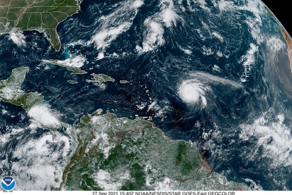
Hurricane Sam is churning across the Atlantic Ocean as a Category 4 storm after it ballooned into a major maelstrom in a few short days.
Still a tropical storm as of Thursday night, Sam intensified into a Category 3 hurricane by Saturday morning, then continued to strengthen. According to the National Hurricane Center, it’s expected to remain a major hurricane for at least another day or two.
Meteorologists don’t expect Hurricane Sam to make landfall in the United States, although it could affect parts of the Caribbean. The storm is expected to curve northward, back out to sea, later this week.
On supporting science journalism
If you're enjoying this article, consider supporting our award-winning journalism by subscribing. By purchasing a subscription you are helping to ensure the future of impactful stories about the discoveries and ideas shaping our world today.
While scientists are hopeful Hurricane Sam won’t cause major destruction before it veers across the ocean, it’s still a symbol of the shifting Atlantic hurricane season—a large, rapidly intensifying cyclone in the midst of another remarkably busy hurricane season.
Atlantic hurricane season is currently at its peak, and it’s showing no signs of slowing down. Sam was the fourth named storm to form in a week and the 18th named storm overall this season. (Named storms include both tropical storms and hurricanes.)
Sam is also the seventh hurricane this season and the fourth one to achieve “major storm” status, meaning a Category 3 or higher.
Shortly after Sam formed, Subtropical Storm Teresa became the 19th named storm of the season. Short-lived Teresa dissipated Saturday after persisting for just a few days.
According to meteorologist Phil Klotzbach at Colorado State University, only one other season in observed history has seen 18 or more storms by this point in the year. That was 2020, the most active hurricane season on record with a staggering 30 named storms by the season’s end in November.
It’s not clear whether 2021 will hit the same bar. But it’s already exceeding early predictions about the season.
Both NOAA and Colorado State University independently issue hurricane season forecasts each year, which they typically update midseason. NOAA’s most recent season outlook—updated in August—predicted anywhere from 15 to 21 named storms by the end of the season, including seven to 10 hurricanes and three to five major hurricanes.
CSU’s outlook, similarly, predicted 18 named storms, including eight hurricanes and four major hurricanes, by the time the season closes at the end of November.
The season has already hit most of those milestones.
Like last year, a number of meteorological conditions lined up to shape this year’s unusually active season, Klotzbach told E&E News. Ocean temperatures have been warmer than usual this year, fueling the formation of storms. Wind conditions also have been favorable for hurricanes.
This year has also seen a strong West African monsoon, a large atmospheric circulation pattern that tends to be active during the summer months. The West African monsoon helps create waves in the atmosphere that can serve as the “seeds” for hurricanes out in the ocean, Klotzbach noted.
“Most storms that have formed since early August have developed from systems that originally formed over Africa,” he wrote in an email.
Last year, warm ocean temperatures and favorable wind conditions also contributed to a busy season (Climatewire, Aug. 21, 2020).
Climate change and cleaner air
With one record-breaking season in the rearview mirror, and another strong season underway, it’s worth asking: Is climate change churning out more hurricanes?
As it turns out, the total number of storms might be something of a red herring.
Climate change is affecting hurricanes in a number of ways. Perhaps most notably, it’s making them more intense. That means there’s a growing probability that any given storm will spin up into a major hurricane.
Recent research finds that hurricanes are getting stronger over time, and models predict it will keep on happening as the planet continues to warm.
But models generally don’t predict much of a change in the total number of storms that form each season. The storms that do form may be stronger, but there probably won’t be more of them overall.
That’s because climate change affects the climate in complex ways. On the one hand, warmer ocean temperatures do help hurricanes form more easily. On the other hand, climate change may also alter the atmosphere and the winds in ways that could inhibit hurricane formation.
With these two opposing forces at work, the total number of storms probably will stay about the same. In some parts of the world, models suggest it might even decrease slightly.
That said, there is some evidence that hurricane activity may have picked up in the Atlantic over the last few decades.
NOAA recently updated the baseline it uses to define an “average,” or normal, hurricane season. The agency typically uses a 30-year average, which it updates every 10 years. Between 1981 and 2010, the previous baseline, the average hurricane season had 12 named storms, including six hurricanes and three major hurricanes.
The new baseline, just updated this year for the period from 1991 to 2020, has an average of 14 named storms, including seven hurricanes and three major hurricanes.
Scientists believe a different human influence, separate from climate change, may be part of the story. Declining air pollution may have helped warm the Atlantic over the last few decades.
Certain types of air pollution can have a cooling influence on the climate—and there was a lot of it throughout much of the 20th century. Scientists believe that pollution, and its associated cooling effects, may have dampened hurricane activity during the first half of the 20th century.
Beginning in the 1970s, however, Europe and the United States began making serious moves to reduce their pollution levels. The Clean Air Act was a key contributor to these efforts. As a result, pollution levels dropped and the Atlantic began to warm at a faster rate.
Scientists believe hurricane activity picked up again in response.
Multiple studies have come to this conclusion. A paper published this summer suggested that recent increases in Atlantic hurricane activity are in fact a recovery from a lull in hurricane activity in the mid-20th century.
So hurricane activity may, indeed, be increasing in the Atlantic—and these past few seasons may be a symptom of it. But in the coming decades, the influence of climate change is likely to present itself in other ways.
Stronger, faster-intensifying storms—like Hurricane Sam, currently charging across the Atlantic—are on the horizon.
Reprinted from E&E News with permission from POLITICO, LLC. Copyright 2021. E&E News provides essential news for energy and environment professionals.