CLIMATEWIRE | At a tiny airport in the northwestern corner of Massachusetts, a weather station feeds precipitation data to a NOAA program that publishes the official precipitation estimates for most of the United States.
NOAA’s precipitation estimates cover almost any U.S. location, and they are crucial to engineers and planners in designing projects such as roads and bridges to withstand the worst downpours.
And that’s why a new report by a leading climate research group calls the North Adams, Mass., station “the most extreme case” of what’s wrong with NOAA’s precipitation data and its disregard for climate change.
On supporting science journalism
If you're enjoying this article, consider supporting our award-winning journalism by subscribing. By purchasing a subscription you are helping to ensure the future of impactful stories about the discoveries and ideas shaping our world today.
The North Adams estimates are based on precipitation records that go back to 1816, which the new report says makes them obsolete and inaccurate because they incorporate 200-year-old data and do not account for the current and future effects of climate change.
The station is unique only in the long time span it covers. At thousands of other weather stations across the United States, NOAA is incorporating decades-old records into current estimates while excluding the effects of climate change. The forecasts are known as the Precipitation-Frequency Atlas of the United States, commonly called Atlas 14.
A report published Monday morning by the nonprofit First Street Foundation warns that new infrastructure projects built today using Atlas 14 data “are instantly decades out of date.”
As a result, the projects are “unable to adequately protect against current and future flood risks from heavy precipitation events,” the report says.
“We’re designing infrastructure generally to the wrong standards for precipitation risk,” said Jeremy Porter, head of climate implications at the foundation. The organization’s previous analyses of how climate change will worsen events such as hurricanes and wildfires is used by agencies including EPA and the Federal Emergency Management Agency.
The report warns that NOAA’s precipitation estimates could cause new construction to be improperly designed and mar infrastructure projects funded from the $1.2 trillion bipartisan infrastructure law of 2021.
The “useful life” of projects funded by the law “will all be based on inaccurate data and result in wasted taxpayer dollars,” the First Street report says.
NOAA did not dispute the First Street report and noted that it is revising Atlas 14 to incorporate climate change. The revision is planned for publication in 2027.
First Street’s analysis puts the spotlight on NOAA’s little-known precipitation forecasts, which are of minimal public interest but are the "authoritative source” for precipitation information and are relied on to design “civil engineering and transportation infrastructure nationwide,” NOAA says.
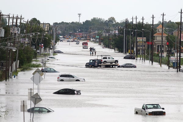
The shortcomings of Atlas 14 have been known for years and drew some attention after Hurricane Harvey dumped record rainfall on southeastern Texas in 2017.
When NOAA published updated precipitation estimates for Texas in 2018, it showed that Houston would receive 18 inches of rain in a 24-hour storm. The previous estimate, written decades earlier, said that an extreme storm in Houston would produce 13 inches of rain in 24 hours.
Some said the inaccuracy of the Houston data contributed to damage caused by Harvey because recent infrastructure projects were built to inadequate precipitation standards.
The foundation’s new analysis suggests the same could happen in other prominent cities such as New York City, Washington, D.C., Dallas and Baltimore, where Atlas 14 projections severely underestimate probable rainfall.
In Baltimore, the analysis says that rainfall has increased so much in recent years that a severe storm projected by Atlas 14 to occur only once in 100 years is actually likely to occur every 14 years. By 2053, Baltimore’s once-in-a-century storm will occur every 12 years.
In Dallas and Washington, the Atlas 14 a once-a-century storm is actually a once-in-21-years storm, the foundation report says.
The analysis also notes that in a one-month span last year from late July to late August, the United States experienced five rainfall events so enormous that Atlas 14 categorized them as once-in-1,000-years events.
Such storms “should no longer be accurately characterized as a 1-in-1,000-year event,” the First Street report says. The description “was accurate approximately 50 years ago.”
The report says that Atlas 14 is inaccurate because it gives equal weight to all of its rainfall records including those from more than 50 years ago, which are less relevant to current conditions than more recent records influenced by climate change.
“The understanding of precipitation expectations today is about 50 years out of date,” the analysis says.
NOAA has acknowledged the inaccuracies and received $492 million from the infrastructure law to improve modeling and mapping programs including Atlas 14, which will be revised and published as Atlas 15.
NOAA would not comment on the First Street analysis but in a statement said Atlas 15 would address current problems and “incorporate historical changes in rainfall intensity” and include “estimates of future climate conditions.”
The infrastructure law provides the “first-ever direct federal funding” to update precipitation records “while accounting for climate change,” NOAA said in an update on Atlas 15. The update calls Atlas 15 the “first national precipitation frequency analysis accounting for climate change.”
Porter of First Street said NOAA has sought funding from Congress “for years to update Atlas 14.”
“It just didn’t seem like the funding was a priority,” Porter said.
Even with the new funding, NOAA says Atlas 15 will not be published in its final form until 2027. The First Street report says the publication date means that billions of dollars from the infrastructure law “will be spent on projects that will not be built to the proper flood design standard.”
The First Street Foundation will update its analysis in July to show the precipitation risk for tens of millions of individual properties in the United States. The foundation's website currently shows various types of climate risk such as flooding for more than 100 million properties.
Reprinted from E&E News with permission from POLITICO, LLC. Copyright 2023. E&E News provides essential news for energy and environment professionals.