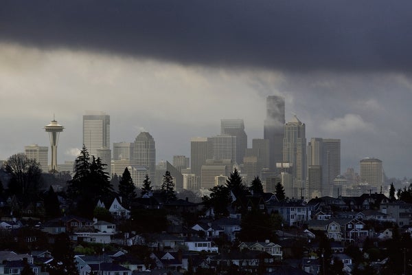
Washington State’s Puget Sound—home to the metropolises of Seattle, Tacoma and Olympia—is a sitting duck for a major earthquake, whether it comes in the form of a deep tremor triggered by a fragmenting tectonic plate, a shallow crustal fracture or an almighty megathrust on the boundary where one tectonic plate tumbles beneath another.
Although nobody can say when the next significant quake will occur or precisely which of the region’s plentiful faults will be responsible, scientists can glean insights into contemporary seismic hazards by assembling a detailed record of the types and frequency of temblors that have rocked the region in the past few thousand years. But finding detailed evidence of major quakes prior to the dawn of modern seismology in the 20th century can be extremely difficult.
Now, thanks to some clever scientific detective work, a catastrophic “hidden” quake has come to light. Using the natural clocks preserved within the carcasses of trees and aided by a mysterious cosmic explosion that showered Earth in radiation, researchers have fairly precisely pinned down a seismic event in the Puget Sound area to within a six-month period in the 10th century C.E. Their results, published on Wednesday in Science Advances, point to the possibility of multiple faults rupturing essentially simultaneously—a risk that is currently not planned for in the area. “It’s showing that these complex, large earthquakes are a real possibility,” says Bryan Black, a dendrochronologist at the University of Arizona and lead author of the new study.
On supporting science journalism
If you're enjoying this article, consider supporting our award-winning journalism by subscribing. By purchasing a subscription you are helping to ensure the future of impactful stories about the discoveries and ideas shaping our world today.
Scientists know plenty of quakes have hit Puget Sound over the past few millennia. But the exact timing and manner of these ruptures is hazy. “Modern seismological instrumentation for global earthquake observations has only been around for a few decades, which is short, compared with the large earthquake cycles of hundreds to thousands of years,” says Zhe Jia, a geophysicist at the Scripps Institution of Oceanography, who wasn’t involved with the new study. “As a result, our observations of earthquake complexities remain limited.”
That means “we have to use creative techniques to help us gather as many clues as we can about past earthquakes, because what happened in the past gives us constraints about what could happen in the future,” says Wendy Bohon, an independent earthquake geologist and science communicator, who also did not take part in the newly reported research.
One way to identify “missing” major quakes is to work out when trees were killed by seismic activity—directly by the shaking itself or indirectly by landslides, tsunamis or other quake-related mass movements. Radiocarbon dating of dead tree material in the Puget Sound region has suggested trees at multiple locations were killed by earthquakes around 1,100 years ago—give or take a few decades to a century or more. That uncertainty is not especially helpful for understanding a region’s seismic hazard potential. “Did these happen 100 years apart? That was a possibility. And that’s a much different seismic hazard than these happening within six months or less,” Black says.
Fortunately, the field of dendrochronology can come to the rescue. Tree trunks have growth rings; each concentric circle represents one year. Sample enough living trees in a region, and you can produce a tree-ring “barcode” that spans the hundreds or thousands of years various tree species can live. If you examine the tree-ring pattern on a dead tree that is preserved by mud and water, you can compare it with the living-tree-ring barcode and work out exactly what year the dead tree perished.
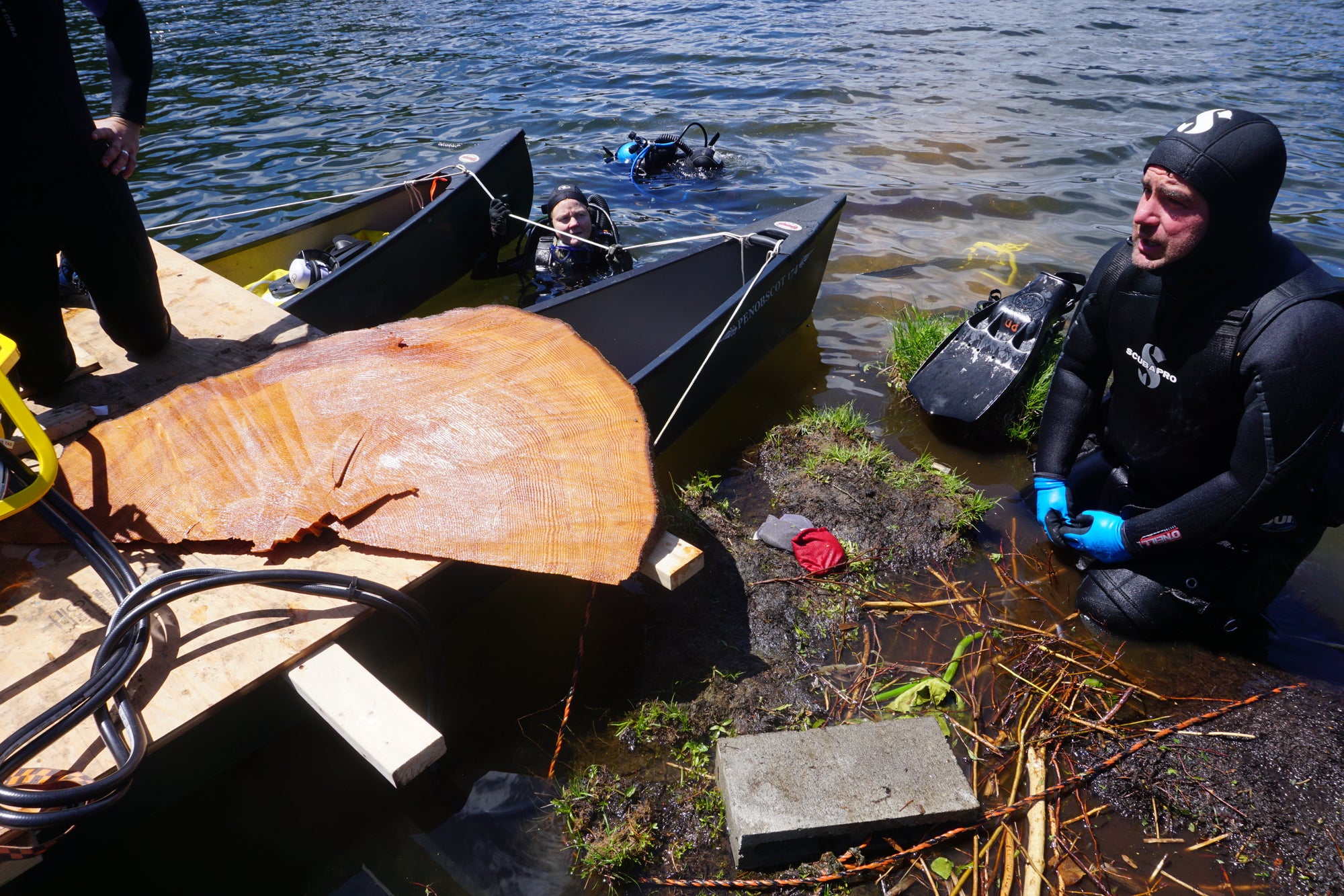
The hydraulic chainsaw and generator used to cut earthquake-killed trees that are submerged in Price Lake, Wash. Credit: Bryan Black
This technique has been previously used to determine the exact years of various cataclysms, ranging from volcanic explosions on the Greek island of Thíra (also called Santorini) to quake-generated tsunamis along the Pacific Northwest’s Cascadia subduction zone. Black’s team applied this forensic technique to dead preserved Douglas-fir-tree samples from multiple locations across Puget Sound, all associated with the area’s active Seattle and Saddle Mountain fault zones. “These were all underwater,” Black says. For example, one swath of trees in Seattle’s Lake Washington were submerged when an ancient, quake-induced landslide carried much of a forest down to the lake’s floor, drowning them.
An enigmatic radioactivity spike also helped the researchers. Between C.E. 774 and 775, trees all over the world recorded an uptick in radiogenic carbon 14 from an unknown but extremely energetic event in space—a potent solar flare or the violent outburst of a dying star or a black hole, perhaps—that sprinkled Earth in radiation. That created a very convenient and extremely well-defined time stamp that anchored those dendrochronological time lines and let the scientists determine that a quake, or quakes, slaughtered all these trees within a six-month period between the late fall of C.E. 923 to the early spring of C.E. 924. “I am in awe of the power this method shows to precisely date earthquakes for which we have no direct historic records,” says Harold Tobin, director of the Pacific Northwest Seismic Network, who wasn’t involved with the new study. “The result seems extraordinarily robust.”
Turning to preexisting geophysical models that simulate the multitude of ways in which a studied fault can rupture, the researchers posit two versions of events that could have killed all those trees over that short time span: One scenario involves two distinct quakes—a magnitude 7.5 on the Seattle fault zone and a magnitude 7.3 on the Saddle Mountain fault zone—separated by a few hours to a few months. The other features a so-called compound earthquake, a single earthquake that happened nearly simultaneously across multiple faults in the region, with an estimated magnitude of 7.8.
That latter possibility in particular has experts concerned about how much they still have to learn about the seismic behavior of the area. “This would produce longer and stronger shaking over a wider area than is currently used in regional disaster planning,” Tobin says. The “one-two punch” of the individual but closely timed quakes is also worrying. “The first can cause damage, and thereby weakening, to both manmade structures and potential landslide slopes that would then fail in the second,” he adds.
The good news is that this is all coming to light before any such quakes have happened in the present. Emergency management plans can be tweaked accordingly, and communities can be better prepared for the days to come. Major quakes like these “are rare, fortunately,” Black says. “But they happen.”