
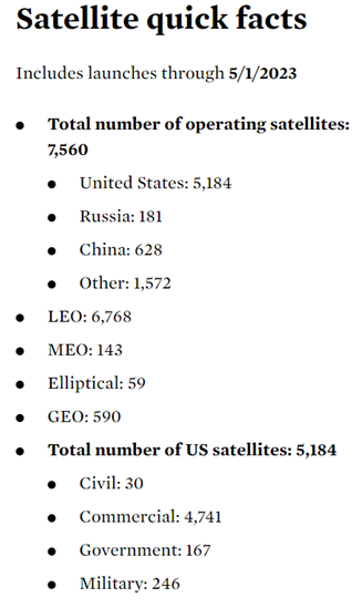
This month, the Global Security Program at the Union of Concerned Scientists released the last UCS Satellite Database to be produced by our incredible longtime colleague, Teri Grimwood. This update, current with launches through May 1, 2023, collects 28 pieces of data on 7,560 actively-operating satellites.
Over the last 18 years, Teri has produced 45 updated versions of our database. The Satellite Database has subscribers from inside and outside governments from all over the globe. That it has become a critical tool for researchers, reporters, policymakers, and space enthusiasts is a testament to Teri’s judgment, vast subject knowledge, and attention to detail. We in the UCS Global Security Program are very proud of this work and its impact.
We began this project in 2005, when we realized there was a significant lack of accurate and public data of this kind. Estimates of how many actively-working satellites were in space varied widely. We could find no place that collected comprehensive data on each satellite, including who built, launched, operated, and owned those satellites; the masses and estimated lifetimes of the satellites; where they operated; and what exactly they were doing.
We wanted to answer questions such as how many satellites each country fielded, what part of space was most intensively used, what was the breakdown of civil versus military versus commercial use of space?
As I wrote upon the 10th anniversary of the UCS Satellite Database, we believed that the issues around the civil and military uses of space would benefit from solidly-researched information describing different states’ investments in space.
The very real issues around space security have only grown more important as space has taken a more central role in the global economy and in global security.
We’ve learned a lot in 18 years
Along the way, we learned a lot about what users need (and don’t need). We always appreciate your feedback. Early on, we realized that database users who were sensitive to classified information could not use the database if it included certain names of satellites, given the long history of classifying the very existence of spy satellites. In response, we regularly produce “clean” versions of the Satellite Database with only the official name of each satellite.
We also learned that a lot of users appreciate when we crunch some of the numbers for them. Because of that, now we include a table of Satellite Quick Facts with every update.
Along the way, researchers and media have produced some spectacular visualizations of the Satellite Database. One of my favorites is from Quartz in 2014.
We’ve tracked changes in space for nearly two decades
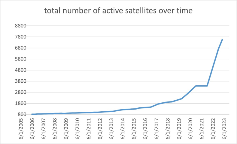
Back in 2005, we counted 810 actively working satellites; almost exactly half of these were owned by the United States. Commercially-owned satellites comprised just about half of all active satellites.
Currently, nearly 70% of the 7,560 active satellites are U.S.-flagged, driven largely by the commercial satellite sector. More than 90% of U.S. satellites are commercial, mainly due to the Starlink constellation which makes up about three-fourths of the U.S. commercial satellite fleet. This growth in the number of satellites has been a real challenge for a project such as this. As you can see from the graph below, the number of active satellites that require accurate data tracking has increased by almost an order of magnitude since we started in 2005.
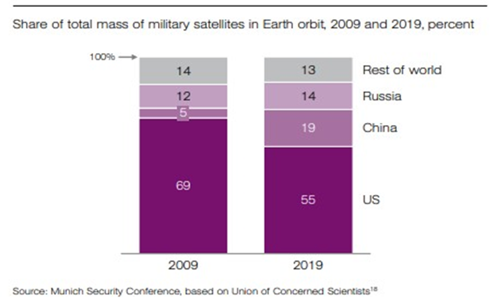
Of course, given the revolution in small satellite use, numbers of satellites are not necessarily the best indicator of capability on orbit. For this reason, we have tried to collect information on the mass of satellites whenever those are available; Mass is a better tracer for capability than total number because more massive satellites can generate more power and carry more equipment to provide more services. The launch masses in the current database range from 1 kilogram to 22,500 kilograms.
In 2020, we worked with the Munich Security Conference researchers to trace how on-orbit military capabilities were evolving, with mass as an indicator:
When we started the Satellite Database in 2005, no satellites had been intentionally destroyed in an anti-satellite (ASAT) test for two decades. Since 2005, there have been destructive, space debris-producing anti-satellite weapons tests by China (2007), the United States (2008), India (2019), and Russia (2021). Our database helps us understand how the physical environment in which these tests are taking place has changed.
In 2007, we counted about 60 active satellites with perigees within 50 kilometers of the altitude at which the Chinese ASAT test target, Fengyun 1-C, a defunct satellite which orbited at about 863 kilometers altitude, was destroyed. Currently (and curiously), not much has changed; about the same number of active satellites live in that region.
However, in other regions of space, the satellite population has grown dramatically and debris-producing ASAT tests or use have the potential to affect many more satellites. In 2007, the region around 480 kilometers was occupied by about 20 actively working satellites. In 2021, Russia destroyed one of its own satellites at that altitude in an ASAT test. (The thousands of Starlink satellites operate just above this altitude band.) More than 950 satellites, owned by dozens of different states, were operating within 50 kilometers of that altitude when the ASAT test took place, and more than 1,200 are operating there currently.
The 2021 satellite destruction generated more than 1,700 pieces of trackable debris and countless smaller pieces that were dangerous to other satellites but could not be tracked. A recent paper by Aaron Boley and Michael Byers looked at how an ASAT satellite destruction might affect a large satellite constellation if the ASAT test or use is conducted at an altitude chosen to create the most havoc. They found that such an event could generate potentially tens of thousands of “conjunctions,” that is collisions between pieces of debris and a satellite, or near-misses that may require avoidance maneuvers by the satellites. These kinds of destructive tests can litter space with debris that persists for decades or centuries and make parts of space more dangerous and expensive to use. This is one reason the United States has been advocating for a norm against destructive, “direct ascent” ASAT tests, both via state commitments and through United Nations processes.
Looking ahead
The Global Security team at UCS plans to continue Teri’s work and keep producing the database. We are working with stellar students from the University of Wisconsin at Madison to automate some of the data collection and validation to keep up with the huge data flow. We plan to get back on tempo with regular updates.
If you’d like email notification when the updates are made, sign up here, and stay tuned. We appreciate your patience as we make the transition!